Wednesday Weekly July 11: Wisconsin and Duluth With Victoria

In last week's Wednesday Weekly I gave you a preview of what I was doing. Victoria came up with me to visit family for the 4th of July weekend. We also did some wedding planning for our Wisconsin reception. Between visiting family, wedding planning, exploring, and just relaxing a bit, I was swamped for time.

As I write this, I'm up in Canada. By the time you read this, I'll be camped out in a tent a in the middle of a field at Rockfest in Cadott, Wisconsin. This July is turning out to be as busy as last July in terms of travel.

The last time Victoria was up was last July. We went up for my buddy's wedding. We did plan to go up for Christmas, but some unfortunate circumstances kept us in Texas.

Planning this trip, it looked like things were going to be good for us to travel north. The plan was for us to leave June 28th and stay until the 4th of July. On the 4th, we'd head up to check out Duluth, Minnesota. From Duluth, we'd head to Minneapolis where we'd spend the night. On the 5th, Victoria would fly back to Austin and I would drive to Thunder Bay for Bluesfest.

Now we were told it was going to be a scorcher in Wisconsin. It was supposed to be in the 90's (around 32C). The funny thing is, that was still cooler than the 100's (around 38C) we were leaving in Texas. Victoria and I got in the car and started driving. We fought the Austin traffic and started heading north. It was also a very windy day.

GPS navigation device mounted on car dashboard showing route directions in a residential neighborhood View from behind vehicle on elevated highway with green overhead sign indicating Route 35 South and Waco exit Car dashboard display showing trip statistics: 100°F temperature, 68.6 miles traveled, 33.5 MPG current, 35.6 MPG average, 383 miles range remaining, and 31,832 total odometer miles Highway view approaching roadside businesses with large Texas state flag flying prominently against blue sky with scattered clouds

We made a pit stop at Slovacek's. I topped off with gas and got a Frito pie.

Exxon gas station and attached restaurant building with multiple vehicles parked in front under clear blue sky Loaded chili cheese fries or Frito pie topped with shredded cheddar cheese, diced onions, jalapeño slices, sour cream, and a sausage link

After eating, we drove into the evening and ended up at the La Quinta in Guthrie, Oklahoma. When Victoria rides up with me, this is our usual stop for the night.

Early evening highway view at dusk with pink and orange sunset sky and roadside billboard visible in distance La Quinta Inn hotel exterior at night with green accent lighting illuminating the entrance and facade

The next morning's sunrise was nice. We hit the road and tried to make as good of time as possible.

Sunset view from hotel parking lot overlooking commercial area with various businesses, parking lots, and highway signs silhouetted against colorful evening sky Highway driving view through rural grassland area under bright blue sky with wispy clouds

In Missouri, we made a pit stop at a Casey's. They make good pizza and this one has a good view by the tables.

Interstate highway view with forested hillside along right side of road under clear morning sky Highway merge area with concrete barriers and overhead lighting, showing typical interstate infrastructure

We drove the rest of the way and finally made it to Wisconsin as the sun was setting.

Rural two-lane highway at sunrise or sunset with fog settled in valleys and wooded hills silhouetted against orange and blue sky Black and white scruffy dog sniffing around rocks and gravel near large reddish boulders Manicured lawn area with decorative white lighthouse feature surrounded by rocks, white ornamental fence, and dense green trees in background

The next morning on Saturday, we had coffee on the porch. Jordy kept us entertained when she would chase birds on the lawn.

Narrow pedestrian suspension bridge with wooden planks spanning across river, surrounded by lush green forest on both sides Lake view showing sandy beaches, boat docks, jet ski, and RV camping area visible among trees on opposite shore under partly cloudy sky

After coffee, Victoria and I headed to North Wood County Park (Richfield). It's only a few miles from my parent's house. It has a suspension bridge, campground, and a lot of good nature to take in.

Rural dirt road stretching straight ahead through corridor of dense green trees and vegetation under blue sky with puffy white clouds View from suspension bridge showing rocky river with scattered boulders flowing through wooded area under partly cloudy sky Wide view of calm lake or river with wooded shoreline in distance, taken from suspension bridge with cable visible in frame Side view of suspension footbridge spanning across grassy area with concrete abutments and stairs, surrounded by trees under blue sky with white clouds Tree-lined paved road curving through dense forest with dappled sunlight creating shadows on pavement

Later that day, it looked like we were going to be hit with some strong storms. Lucky our next activity was indoors. We watched my brother's band Husky Trumpet at the Chestnut Center for the Arts.

Weather radar map on smartphone showing mixed precipitation system moving through Minnesota and Wisconsin with Marshfield, Wisconsin location marked, displaying rain and snow at 5:22 PM Weather alert screen on smartphone showing Excessive Heat Warning and Severe Thunderstorm Watch for Marshfield, Wisconsin area with map showing affected regions Band performing on stage in community center or gymnasium with green and blue stage lighting, multiple musicians with instruments and speakers visible

The Chestnut Center for the Arts doesn't have air conditioning. It was hot for Wisconsin standards, but still better than Texas.

Weather app showing Austin, Texas temperature of 101°F with sunny conditions and feels-like temperature of 101°F at 3:15 PM Weather app displaying Marshfield area temperature of 83°F with mostly cloudy conditions and feels-like temperature of 87°F in Sherwood, Wisconsin

After listening to my brother's band, we met up with my buddy Jake and his fiancee and also my friend Caleb. We sat for a while at the brewpub and then headed to Nutz Deep.

On Sunday, we headed to church and said hi to the deacon who would be doing our Wisconsin wedding ceremony. From there, Victoria and I visited my grandmas and then had a late lunch at my parent's house. My brother and his girlfriend also came out.

Monday morning we first talked with the wedding venue. Then we decided to get some Chip's for brunch.

Fast food meal on blue tray featuring sesame seed burger with coleslaw, crinkle-cut fries, and breaded cheese nuggets on Culver's branded paper

We drove around a bit and explored the area while our food settled. Of course we ended up getting stuck waiting for a train.

Railroad crossing with lowered gates, warning lights, and CN freight train passing through small downtown area under clear blue sky Same railroad crossing moments later showing CN freight train continuing through crossing with buildings and parked vehicles visible in background

Once our food settled, we headed to Hub City Ice Cream.

Hub City Ice Cream Company sign on pole against blue sky with row of trucks parked in background and street signs visible

From there, we headed to Neillsville to talk to a caterer. We got to see the old historic downtown.

White gazebo decorated with American flags and hanging flower baskets on town square with storefronts and Sherwood bank sign visible in background Small-town main street showing mixed-age commercial buildings including green two-story structure housing antique shop with pickup truck parked in front Downtown main street view with decorative street lamps, hanging flower baskets, historic commercial buildings, and Sherwood bank building on corner

Since we were in the area, we drove over to Hatfield. I showed Victoria Russell Memorial Park. I used to camp here all the time as a kid. They were working on the dam so the water was much lower than I remembered.

Entrance sign for Clark County Russell Memorial Park & Campground along wooded roadway with pine trees and paved path Sandy beach along large lake with scattered beachgoers in water, forested shoreline visible across lake under blue sky with scattered clouds Lake view showing sandy beaches, boat docks, jet ski, and RV camping area visible among trees on opposite shore under partly cloudy sky

It didn't take long to get through the campground and we still had a little time to kill. I took the scenic way back and swung by Pray. I took some of the gravel roads and showed Victoria the place my buddies and I hung out and shot shotguns. We made sure to look out for Amish buggies along the way.

Rural dirt road stretching straight ahead through corridor of dense green trees and vegetation under blue sky with puffy white clouds Rural two-lane highway stretching straight ahead with yellow road sign indicating dead end or no outlet, trees and abandoned house visible on right side

On Tuesday, we went to Five-O-One and had a pizza.

Whole cheese pizza cut into squares on dark surface, showing melted mozzarella and visible browned spots from baking

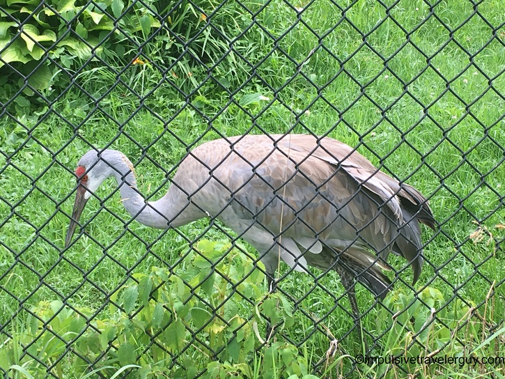
We did some more exploring around town. We went to Wildwood Zoo.

Overcast view of lake from wooden fishing pier or dock, with residential buildings and trees visible along far shoreline Calm lake reflection view with trees and buildings mirrored in still water, vegetation in foreground, under gray cloudy sky Wildwood Zoo entrance sign displaying summer hours and admission information, with chain-link fence gate and wooded enclosures visible beyond Natural pond or wetland habitat at zoo with rocky shoreline, small island, surrounded by mature trees and green grass Low brown brick building with decorative murals and wildlife artwork panels mounted between windows along exterior wall Wooden sign reading Bear Woods sponsored by Wildwood Zoological Society with bear silhouette, mounted on chain-link fence Zoo exhibit showing sandy terrain with tree stumps and logs in enclosure, weathered blue-green painted walls visible Overhead metal truss structure labeled Floyd & Pat Hamus Bridge and JP Adler Family Kodiak Bear Exhibit spanning zoo pathway Sandhill crane standing in grassy enclosure viewed through chain-link fence, showing characteristic red crown and gray plumage

Our visit to Marshfield went fast! Wednesday was the 4th of July and it was time to head up north to Duluth. The weather was nice in Marshfield, but started turning kind of nasty after our pit stop at an A&W.

Urban intersection with divided roadway, traffic lights, manicured median with grass slopes, and trees in background Weather app showing Marshfield, Wisconsin at 81°F with mostly sunny conditions, feels like 86°F, high 89°F low 71°F at 10:43 AM Weather radar map on smartphone showing large storm system moving through Minnesota and Wisconsin with Marshfield marked, displaying mixed precipitation at 10:40 AM A&W fast food meal on purple tray featuring burger with lettuce, French fries, cheese curds, and soft drink with Sweets & Treats placemat Highway driving through rain with water droplets covering windshield, dark storm clouds overhead, vehicle ahead visible on wet pavement Driving through heavy rain on highway with windshield covered in water droplets, dark storm clouds, vehicle ahead visible through downpour Highway view approaching dark ominous storm clouds with Tomah exit sign visible, threatening weather conditions ahead Highway view showing dramatic dark storm clouds with lighter area on left side creating stark contrast, wet pavement visible Highway driving view under heavy gray storm clouds with some light breaking through, flat agricultural fields on both sides, overpass bridge ahead Wide empty highway with water droplets on windshield after rain, overcast sky, trees lining both sides of road

By the time we got to Superior, it was clear.

Rural highway curving upward through tree-lined corridor, grassy slopes on both sides under clearing blue sky

The clear weather didn't last long when we parked in Duluth. It was a bit cloudy and eventually got foggy. We checked out the Maritime Visitor Center. We then walked around the shipping pier and Canal Park. We tried to go to Electric Fetus, but it was closed. Overall, it was a nice scenic walk and we enjoyed the views of Lake Superior.

Foggy parking lot at waterfront location with multiple parked vehicles, people gathered near water, seagulls flying overhead under heavy gray sky View from lakeside park showing iconic Aerial Lift Bridge structure with visitors walking on grass, ornamental lamp post, lighthouse visible in distance under cloudy sky Close-up view of Aerial Lift Bridge's steel truss structure spanning across canal with small boat dock visible below under overcast sky Park scene with people making giant bubbles using long poles, seagulls flying overhead, lift bridge and city buildings visible in misty background Long concrete breakwater pier extending into lake with iconic lift bridge visible in distance, visitors fishing and walking along pier under gray sky Lake Superior lighthouse with red roof on concrete breakwater pier, surrounded by choppy water under foggy overcast conditions View down long breakwater pier toward lift bridge with visitors walking and fishing, people visible along edges under foggy gray sky Large vintage ship anchor on display with chain on rocky shoreline, visitors exploring rocks near water, misty conditions with hills visible across lake Downtown main street view with brick median dividing lanes, decorative lamp posts, parked vehicles, tree-lined street under cloudy sky Urban bridge crossing with multi-story buildings visible, church tower in background, concrete barriers along roadway under overcast sky Street-level view of retail storefront with Clothe signage visible on white tile facade, adjacent brick building, sidewalk with pedestrians Arched gateway sign reading Lake Place Lakewalk mounted on building wall, trees and pathway visible beyond Elevated view looking down steep downtown street with mix of historic and modern buildings, parked vehicles along sides, wet pavement under cloudy sky Lakewalk path alongside railroad tracks with blue retaining wall, people walking below near rocky shoreline, Lake Superior visible under foggy conditions Wide rocky beach along Lake Superior with scattered visitors, paved pathway visible at edge, misty foggy conditions obscuring horizon Wooden boardwalk paralleling paved path along Lake Superior shore, visitors walking, buildings visible on grassy area to right under overcast sky Lake Superior shoreline with rocky breakwater extending into water, decorative lamp post, ships visible in distant fog, visitors on shoreline Foggy view of Aerial Lift Bridge shrouded in mist with small building and parking area in foreground, evergreen trees framing scene under heavy gray sky Aerial Lift Bridge heavily obscured by dense fog with silhouettes of evergreen trees and smaller pedestrian bridge visible in foreground Rocky Lake Superior shoreline with two people in pink jackets exploring rocks near water's edge, dense fog obscuring horizon, green vegetation on right

Looking at the radar, it seemed like we were going to hit some storms on the way to Minneapolis. The drive itself was decent and we ended up at the La Quinta we stayed at last time.

Weather app showing Duluth, Minnesota at 78°F with mostly cloudy conditions, feels like 78°F, high 79°F low 64°F, wind speed 10 mph at 4:48 PM Weather radar map on smartphone showing storm systems across Upper Midwest with Duluth marked, displaying mixed precipitation moving through region at 4:45 PM Wide suburban highway with sparse traffic, buildings visible on left, dense tree line on right side under clear blue sky

After all the driving, we were tired. We also had to be up at 3:30am so Victoria could get to the airport on time. We fell asleep and the morning came fast. I was soon dropping Victoria off at the airport.

Night view approaching international border crossing with covered pedestrian walkway overhead, illuminated border checkpoint area ahead, traffic signs and barriers visible

I had a long day ahead of me driving to Thunder Bay. I should have those blog entries written for next week, but I can tell you my visit there so far has been great! You'll have to stay tuned for that adventure, along with my adventure at Rockfest!

See more blog entries here