Fall Colors in Thunder Bay

I always love visiting Thunder Bay and try to visit as often as possible. But, crazily enough, I would visit more when I lived half the continent in Texas than I do now in Wisconsin. Obviously, many things have changed since I moved back to Wisconsin almost three years ago. First, the pandemic closed the border. Then came the birth of my son Austin in February of this year.

We've finally got to the point where I can take two-night overnight trips. Austin is sleep-trained well enough that my being gone over a weekend is fine. With that being said, I'm only shooting to travel once a month or less.

The biggest thing for getting to Thunder Bay is getting there before winter. Last year, I visited in November, and it was snowing on my way back. The drive from the Madison area to Thunder Bay takes 8-9 hours in normal conditions. This means you'll spend the good part of two days driving back and forth. When you throw snow or any winter weather into the mix, it will slow you down substantially and take much longer.

That said, I wanted to visit Thunder Bay at least once this year. I decided to visit counties for my September trip since the days would be longer. It would also be warmer outside. Daylight didn't matter as much for visiting Thunder Bay. I was planning on hanging out with friends and not trying to visit as many counties as possible.

I figured a trip in October would still be fine in terms of winter weather. However, the closer I got to my planned date, the less it looked like that would be the case.

Weather forecast app showing Thunder Bay, CA with 10-day outlook for October 13-22, 2022, displaying mostly cloudy conditions with temperatures in the 30s-40s°F

I decided to take Friday off and hit the road right after I fed Austin and Victoria left to drop him off at daycare. I'd also walk Maya. That Thursday, I decided to get gas and was pelted with a bunch of ice.

White car at Kwik Trip gas station fuel pump with red and blue handles Sidewalk showing three different pavement textures side by side - rough aggregate, smooth tan concrete, and brick pavers, with fallen leaves on grass

The following day, on that Friday, I woke up, and the radar didn't look good.

Weather radar map on mobile device showing precipitation around Belleville, Wisconsin with radar returns visible near Thunder Bay, Madison, and Chicago

I went about my regular morning routine of feeding Austin and getting him ready for daycare. Victoria then took him to daycare on her way to work. I then walked Maya and put her in her crate.

White dog with black spots on leash walking down residential sidewalk between green lawns

To minimize stopping, I also purchased some food for the way.

Road trip snacks on car seat including Kirkland beef steak strips, Snyder's pretzels, and energy drinks

I hit the road and tried to make the best time I could.

Rural highway with West US Route 12 shield sign under cloudy skies with fall foliage on hillsides

When I got close to Eau Claire, the weather turned nasty. First, it started snowing kind of hard, and eventually, the snow began to stick.

Highway driving in light snow with Interstate 94 West sign visible, evergreen trees lining the road Two-lane highway with frost or light snow covering the ground, fall foliage, and merge arrow sign

The drive to Thunder Bay is pretty much a straight shot on only a few roads. You first get to I-94, and then it's a long drive to Superior.

Highway with overhead bridge and green distance sign showing Bloomer 8 miles, Cameron 34 miles, Superior 130 miles

You then get on MN-61, and it's a long drive up that road to the Canadian border and, ultimately, Thunder Bay.

Highway with green distance sign indicating Two Harbors 20 miles, Grand Marais 104 miles, Canadian Border 145 miles, with fall colors visible

The drive up MN-61 can be obnoxious with the sheer amount of slow drivers. Much of the way has a 60mph speed limit, but it's not uncommon for people to be doing 45-50mph. In addition, the road is very windy, and much of it is a no-passing zone. So you and a bunch of cars get stuck behind a slowpoke doing well under the speed limit.

Two-lane highway through autumn landscape with red car ahead, yellow and green foliage on both sides

I don't know how many slow pokes I passed in the rare passing zones, but I finally got close to the Canadian border.

Wet highway in rain with windshield water droplets and green sign for Canadian Border visible ahead

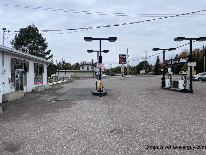
Since gas is much cheaper in the USA, I filled up at Ryden's before crossing.

Gas station forecourt in overcast weather with fuel pumps under covered canopy

The border crossing was pretty fast, and I was soon on ON-61.

Ontario Highway 61 North shield sign with crown symbol at roadside with fall foliage

The interesting thing is the tides turned in terms of driving. Traffic was pretty light, but I was the one being passed this time. I made it to Thunder Bay and went straight to the ATM to get some local currency.

TD Canada Trust ATM screen showing withdrawal options in Canadian dollars with green Interac branding Hand holding Canadian $50 bill with additional bills visible, person sitting in car with steering wheel visible

I then went to Canada's original sub chain, Mr. Sub.

Mr. Sub restaurant exterior with red signage, several cars parked in front

I got their famous Assorted Sub with some all dressed chips and a cookie.

Sub sandwich on paper with ham, vegetables, and cheese, served with Ruffles chips and chocolate chip cookie

I then dropped by my friend Daniel's house. He lives next to the high school football stadium. We watched the Westgate vs. Hammarskjold game from his deck. Daniel coaches the junior Westgate team, so he was cheering on the senior team that was playing. They were victorious while playing in some early winter weather.

Night football game at illuminated stadium with teams on field, viewed through chain-link fence, stadium lights and apartment building visible in background

Daniel tagged along with me to meet my friend Ryan and Matt at Neebing Roadhouse.

Illuminated Neebing Roadhouse sign at night displaying NOW OPEN with hours Sun-Wed 4pm-11pm, Thurs-Sat 12pm-12am on Highway 61

Of course, they had a hockey game playing while we were there.

Television screen showing TSN hockey broadcast of NYR vs WPG game, score 1-2 in 3rd period at 3:58, with Canada Life advertising boards visible

I hit the water hard to stay hydrated and had a good time visiting with everyone.

Glass of ice water with condensation on wooden restaurant table, Eastbound Brewing coaster visible in background

I was starting to check out hotels and noticed they had doubled in price since last year.

Mobile phone displaying Google search results for Prince Arthur Waterfront Hotel with booking options from Booking.com, Expedia, and Hotels.com showing prices CA$197-211 Mobile phone showing The Courthouse Hotel Thunder Bay booking page, described as laid-back hotel in former courthouse, with pricing options CA$240-253 from various booking sites

It was around 1 AM when we left. Since I was meeting Ryan at 8:30 to do some exploring, I wasn't about to pay around $30 CAD an hour for a hotel room. So I dropped Ryan off at home and then figured I'd catch some shuteye in the parking lot near Boulevard Lake.

Nighttime view from inside parked car showing dark parking lot with single street light illuminating trees in background

Just about the time I was starting to doze off, a truck pulled up next to me. It was a security guard telling me I couldn't be there. I then left and drove a bit out of town. I found a road near a nature preserve and was able to sleep the rest of the night.

When I woke up, I went back into Thunder Bay. I got Tim Horton's for breakfast. I got the B.E.L.T. This was like a BLT, but with egg on an everything bagel.

Modern coffee shop exterior at dawn with stone and brick facade, three pendant lights over entrance, accessible parking space, and traffic light visible Tim Hortons breakfast on tray with sesame seed bagel sandwich, hash brown, and coffee in Canadian flag sleeve

I picked up Ryan, and we hit the road for Nipigon.

Green highway distance sign showing Nipigon 27 km, Cochrane 642 km, Sault Ste. Marie 605 km, with highway stretching ahead under cloudy sky Hillside showing forest with many dead or bare trees intermixed with evergreens, evidence of fire damage or logging, under gray sky Blue bilingual population sign reading Township of/Canton de Nipigon Population 1700 along highway with evergreen trees and golden field

It looked like everything was closed downtown, so we headed to the marina.

Wooden dock extending into mirror-calm lake perfectly reflecting forested hillside with mixed evergreen and deciduous trees under overcast sky

Since I was running on limited sleep, I stopped by Petro Canada to get an energy drink. I was happy to see they even had EV charging.

Petro-Canada gas station with red and white branding, modern stone facade exterior under cloudy sky in northern Ontario Two red Petro-Canada electric vehicle charging stations in parking lot with evergreen forest and cloudy sky in background

We intended to get to Terrace Bay. So we hit the road, and I'd stop for pictures every once in a while.

Maximum speed limit 90 km/h sign along highway with evergreen forest on both sides and dramatic storm clouds overhead Two-lane highway with low-lying fog obscuring forested hills in distance, fall colors visible on hillsides Empty two-lane highway through rock cut with exposed granite cliff on right side, mixed evergreen and deciduous forest, overcast sky

Ryan made sure to get a few pictures of his own.

Person in gray hoodie standing on highway shoulder next to silver car near maximum 90 km/h speed limit sign, fall foliage background

Eventually, we made it to Schreiber.

Blue bilingual population sign reading Township of/Canton de Schreiber Population 1100 along highway with evergreen forest and partly cloudy sky Small northern Ontario town with white building and wooden fence, dramatic cliff face covered in fall foliage and evergreens rising behind Wide main street through small northern Ontario town under dramatic dark storm clouds, commercial buildings lining both sides, forested hills visible in background

We went downtown and checked it out.

Green bilingual directional signs pointing left showing Winnipeg Street and Business Section/Quartier des Affaires along highway in small town Small downtown street with mix of white and brick commercial buildings, parked vehicles, forested hillside at end of street under overcast sky World War I memorial monument with granite obelisk inscribed 1914-1918 and LEST WE FORGET, flanked by three flags including Ontario and Canadian flags

For time's sake, we decided to head back toward Thunder Bay instead of going to Terrace Bay. We found a wayside with some excellent views.

Wet waterfront parking area with public restrooms on left, gazebo and parked silver car visible, body of water in background under cloudy sky with fall foliage Rocky shoreline with vibrant red fall foliage shrubs in foreground, calm gray water and forested island visible across lake under overcast sky Park ground completely carpeted with yellow fallen leaves, picnic tables scattered among birch and poplar trees in peak fall color

Before you knew it, we were back in Nipigon. We decided to stop at China Gardens for lunch.

Two-lane highway passing through rock cut with tall exposed granite cliff face on right, mixed fall foliage visible on hillsides China Gardens Chinese restaurant in small commercial building with red awning signage, gray and white painted exterior walls

The funny thing is this Chinese restaurant had pizza, so we got that.

Medium pepperoni pizza in cardboard delivery box, cut into 8 slices with melted mozzarella cheese

After eating, our next stop was the Nipigon General Store. It was only short walk down the street.

Small town main street with red brick building, parked vehicles including burgundy van, decorative black street lamp, yellow fire hydrant, forested hills in background General Store storefront with green lettering on white and beige facade, windows filled with elaborate Halloween decorations including hanging ghost figures Store interior heavily decorated for Halloween with purple fabric draped from ceiling, aisles packed with costumes, seasonal decorations, and orange pumpkin displays

Ryan and I said hi to Terry and Ann, the owners of Nipigon General Store. We visited for a while, and Terry had me sign the ceiling tile for guests that visited in 2022.

White canvas or tablecloth covered in numerous hand-drawn doodles, sketches, and handwritten messages in black marker on store counter

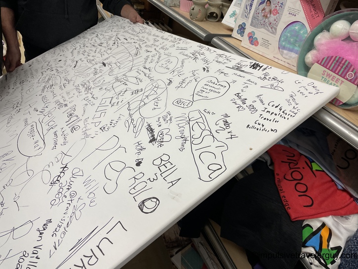
I'm also always looking to experiment with gadgets to improve my road trips. I found a solar-powered battery bank. The general store truly has everything!

Hand holding packaged iFocus 2,700 mAh solar power bank with black device visible through clear plastic clamshell packaging

Our final stop in Nipigon was the lookout tower to take in the incredible views.

Modern angular steel observation tower with zigzag staircase and viewing platform at top, nipigon text on white concrete base with blue sky White cable-stayed bridge with three towers and numerous support cables spanning forested river valley, viewed from observation point showing autumn landscape Elevated panoramic view of northern Ontario landscape with winding river or lake through forested hills, cemetery in foreground, dramatic clouds overhead

On the way back to Thunder Bay, we stopped at Crystal Beach Variety to say hi to John. I actually found out John sold the business and retired (if you're reading this, John, happy retirement!).

Some bacon-flavored chips and dried sausage caught my eye.

Person standing at Suny self-serve gas station pump island, small white service building on left, rural setting under overcast sky Hand holding white bag of Old Dutch Crispy Bacon flavored potato chips with Chubber branded meat stick attached on top

Ryan and I then went to Compass Foods. This is an entirely plant-based vegan store. I've never seen a fully vegan store, so it was cool to check it out.

Commercial strip mall with blue corrugated metal upper facade, Compass Coffee logo sign visible, tan brick lower facade with large glass windows and covered walkway Modern Compass Coffee shop interior with white walls, circular logo featuring compass and dog, white slatwall shelving displaying various products, gray flooring

I bought some vegan jerky to try out.

Hand holding two packages of plant-based jerky - Noble Jerky vegan original in black package and Pan's Mushroom Jerky original in orange package with mushroom illustrations

I dropped Ryan off at home and then drove to the Prince Arthur. I found out they wanted $250 CAD a night for a room. I decided to check out the Courthouse Hotel, and they wanted the same price. While I like the Prince Arthur, you get more bang for your buck at the Courthouse Hotel.

I planned to go drinking that night with my friends, so sleeping in the car wasn't an option. I also wanted to be within walking distance of downtown. So I splurged a bit with the most expensive hotel I've stayed at and checked in to the Courthouse Hotel.

Courthouse Hotel illuminated blue monument sign on red brick base showing illustrated yellow building facade, positioned along roadside with fall foliage Modern hotel room with king bed featuring black leather headboard, white linens with gray and blue decorative runner, rolled towels, large window with sheer and gray curtains Elevated view from hotel window overlooking Thunder Bay waterfront town with prominent tall historic building, commercial buildings, residential areas, and body of water under cloudy sky

To get some white noise going, I set up my USB fan. This is a great travel hack I've found that helps a ton sleeping in both a hotel room or in the car.

Hotel nightstand with digital alarm clock displaying 4:56 and small black metal desk fan on dark wood surface

I fell asleep for a few hours, and it was dark when I woke up.

Nighttime aerial view of illuminated small town with prominent lit multi-story building at center, surrounding commercial and residential buildings under dark blue sky

I was hungry. I went to Alley's Corner Variety to get some chicken tenders and fries.

Alley's Corner Variety convenience store at night with illuminated Pepsi sign, brown brick and beige painted exterior, security gate on door, red SUV parked outside Interior of convenience store with fluorescent lighting, multiple aisles stocked with snacks and beverages, ice freezer with blue signage at back, white tile floor Fish and chips takeout meal in car on paper wrappers - two pieces of battered fish and portion of french fries, steering wheel visible

I made it back to the hotel and got ready to go downtown. I walked a few blocks to Waterhouse.

Small town intersection at night with traffic lights, street lights, low commercial buildings on corners, empty streets Downtown street at night with parked cars along both sides, young street trees with protective grates, historic commercial buildings with lit storefronts Exterior building signage at night showing Waterhouse in black lettering with Coors The Waterhouse banner above featuring rock hand gesture logo

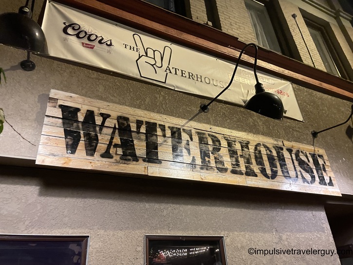
I always love to order a Caesar (Canadian Bloody Mary) when I'm in Canada. All my friends arrived in the meantime.

Caesar cocktail with salt-rimmed glass garnished with large pickle spear, olives, lime, and celery stalk on wooden bar, Jägermeister bar mat visible

After the Caesar, I switched to beer. I was able to show my friends a little party trick.

Craft beer can on dark bar surface, colorful label with red, green and yellow design visible

After Waterhouse, our next stop was Bar Keep. This is a fancier bar with a laid-back atmosphere.

Upscale dimly lit cocktail bar interior with curved white marble bar, dramatic arched backlit display with liquor bottles, dark walls, patrons seated at bar

I had a Lakehead Beer Company light lager. It was really good!

Port Huron Brewing Company craft beer can on white bar surface with black cocktail napkin, black and white label design

The awesome thing is Lakehead Beer Company was a short walk away. So that was our next stop, and I got to drink some more of their great beer.

Industrial brewery restaurant interior with exposed stainless steel brewing tanks on left, wooden tables and chairs, exposed brick and dark walls, warm pendant lighting Large glass beer mug filled with golden lager on rustic wooden table with decorative metal studs, white foam head visible

I ran into my friend Thomas there. I hadn't seen him in years, so it was a great coincidence to see him. After talking to him for a while, I rejoined the group. We decided to check out the club since one of Ryan's friends was there.

Downtown nighttime street scene with businesses featuring illuminated blue signage, crowd gathered outside venue entrance, wooden planters on sidewalk Indoor concert venue with live band on stage, dramatic colored stage lighting including blue, green and yellow beams, crowd of concert-goers in foreground, hazy atmosphere

It was getting close to bar close, so we got to On Deck and ordered a pitcher immediately so we could visit a little longer.

Dark nighttime upward view of building exterior with ROCK text visible on illuminated awning or sign Large glass pitcher of Coors Banquet beer with smaller glass beside it on carved wooden table, both filled with golden beer

We then left and headed our separate ways. I walked back to the hotel.

Nighttime view of illuminated neoclassical courthouse building with columned portico situated on grassy hill, dark sky above, sidewalk in foreground

I tried to get as much sleep as I could before heading back. The morning came fast.

Dawn view from hotel window overlooking Thunder Bay with prominent historic building, residential and commercial structures, body of water visible, dramatic sunrise clouds

I drove to my last stop before the border, Metro, to buy some groceries.

Metro grocery store exterior with large red lettering, modern curved glass entrance facade, rows of shopping carts outside under overcast sky Shopping cart interior view from above containing groceries including yellow Schneiders mini sausages package, red Selection pasta bags, bento box with discount sticker

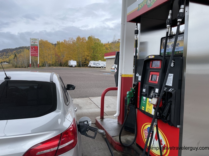
I realized I'd cut it close for gas, so I got a splash of more expensive Canadian gas.

Car dashboard trip computer display showing Trip 1 statistics: 372.2 miles traveled, 37.9 MPG average, 89 miles electric range, 143,068 total odometer miles, 39°F outside temperature Esso gas station with red and white Synergy branding, fuel pump in foreground, convenience store building behind with product displays visible, overcast conditions

I made it to the border, and there was a bit of a line to cross.

Highway traffic view with blue Honda Civic ahead, line of vehicles, evergreen and deciduous trees lining roadside, fall colors visible under gray sky

I waited a while, but talking to the border agent was pretty fast, and I was soon back in the USA. So I stopped at Ryden's again to get a full tank of gas.

White car fueling at gas station pump with autumn foliage on hillside, RVs and vehicles visible in background parking area under cloudy sky

I was then headed down the North Shore for the long drive to Duluth.

Highway view through windshield with green distance sign ahead showing Beaver River and Lesser Slave Lake, mixed evergreen and golden fall foliage, overcast sky

I was close enough to Wisconsin when the Packer game started, so I was able to listen to it along the way.

Car infotainment touchscreen displaying FM radio tuned to 99.7 with radio icon, temperature reading 45°F, time 11:57, AutStore/Direct/Info menu tabs

The Packers played horribly, and it was miserable to listen to them as I drove the long stretches back.

Multi-lane highway with green overhead distance sign indicating Exit 23 for South/Eau Claire, fall foliage and mixed forest on both sides under gray clouds Multi-lane divided highway with overhead gantry signs showing Routes 53 and 35, dramatic dark storm clouds overhead, sparse traffic visible Highway view with Exit 176 sign and Wisconsin Routes 12/90 shields visible, flat agricultural land on both sides, scattered trees with fall color, overcast sky

I eventually made it back to Belleville around 6:30 PM.

Dusk highway driving with vehicle headlights illuminated, dark clouds overhead, commercial buildings and tall light pole visible ahead in distance

I was pretty exhausted when I came back. I was happy that I was able to make it to Thunder Bay, but it was now time to relax. I definitely missed Victoria, Austin, and Maya, so it was good to see them again. Now that winter is closing in, I'm unsure how many more long trips I will take. I'll probably wait until spring. I'll definitely make sure to check out local places, and I know the Madison area has a lot to offer.

-e

See more blog entries here