35 Counties in North Dakota and Montana

Since we’ve adopted our dog Maya, I’ve changed my travel strategy a bit. We do not want to leave her in her crate for an extended amount of time, so I’ve stopped traveling during the week when Victoria is still working in the office.

I get done with my job at 1 PM on Fridays, so we figured it would be reasonable for me to leave right after work on Friday and Maya could spend a few hours in her crate while waiting for Victoria to come home. We’ve run errands in the past for several hours and those few hours didn’t seem to phase Maya staying in her crate.

Eventually, we may look into a doggy daycare situation so I can take extended weekends and travel. In the meantime, there are enough close counties I still need to visit so I’ve adopted what I call the “Dalhart Strategy.”

When I first started visiting counties in Texas, I looked to find the furthest county from where I lived. I found that Dallam County was the furthest away and it took 9 hours to get there (El Paso was a close second at 8.5 hours). I figured I’d start with the furthest counties to get the longest trips out of the way first.

I found I could leave at 1 PM on a Friday right after work and then drive 9 hours to get to where I needed to be and it wouldn’t be terribly late. I’d then try to visit as many counties as I could on Saturday and make my way back to Austin on Sunday.

I'd try to pick up a few counties along the way on the way back. This would allow me to maximize the weekend and be home to work during the week. This strategy worked well and got easier as time went on since the counties became closer and closer.

At the time, my visiting counties was strictly limited to Texas. Currently, I’m trying to visit every county in the USA, so state borders are kind of irrelevant when I plan my trips. I’m just trying to find what clusters of counties make the most sense to visit together from an efficiency standpoint (I still have a full-time job outside of traveling so I have to maximize my off time).

Since I do not draw the line at state borders, there are now a lot of “Dalharts” that I can go to and use this strategy.

Map interface showing a route through the Upper Midwest United States with a folder marked

As you can see, I will be busy for a while and this strategy should serve me well for a bit. With that being said, this trip to North Dakota and Montana was done over Memorial Day Weekend. Because I had an extra day I could use on the road since Victoria would be home with Maya, I would use that time to go a bit further than I could over a normal weekend.

The Dalhart Strategy said I could make it to Grand Forks, North Dakota in around 9 hours. From there, I would skirt the Canadian border and visit some of the northernmost counties in North Dakota and Montana.

After I got done with work at 1 PM on Friday, I hit the road. I-94 was going to be a good chunk of my driving both there and back.

View through car windshield of Interstate 94 West sign along rural Wisconsin highway with grassy median and rolling hills

Being that it was a holiday weekend, everyone had the same idea to get out and travel. While I specifically chose some of the most desolate parts of the country to go to, I still had to drive on some main roads that connected major population centers. I didn’t even make it out of Wisconsin before my first traffic jam. As you can see, I had the parking brake on waiting for this one.

Driver's perspective from inside vehicle showing steering wheel, dashboard displays, and traffic ahead on two-lane highway with semi-truck

I didn’t see an accident, disabled vehicle, or someone pulled over by a cop along the way after traffic started moving again. Either that was cleared before I got there, or the volume of traffic was just that great.

I eventually made it to Minnesota.

Highway scene from driver's seat with visible sun glare on windshield and vehicles ahead on rural road

I had another snag or two around Minneapolis, but west of the city became open roads and it was a long straight drive to North Dakota.

Sunset view through windshield on flat rural highway with utility poles silhouetted against orange and blue sky Evening highway scene approaching Fargo with overhead sign reading

I finally made it to Grand Forks around 11 PM. I looked for somewhere I could park the car for the night and get some sleep. I settled on the parking lot outside of Riverside Dam. It made for some good pictures in the morning!

Illuminated information kiosk labeled Tranquil river scene at dusk with calm water reflecting pink sunset sky, tree-lined banks, and rocky shoreline in foreground Rocky river with flowing water and bridge visible in background under pastel evening sky

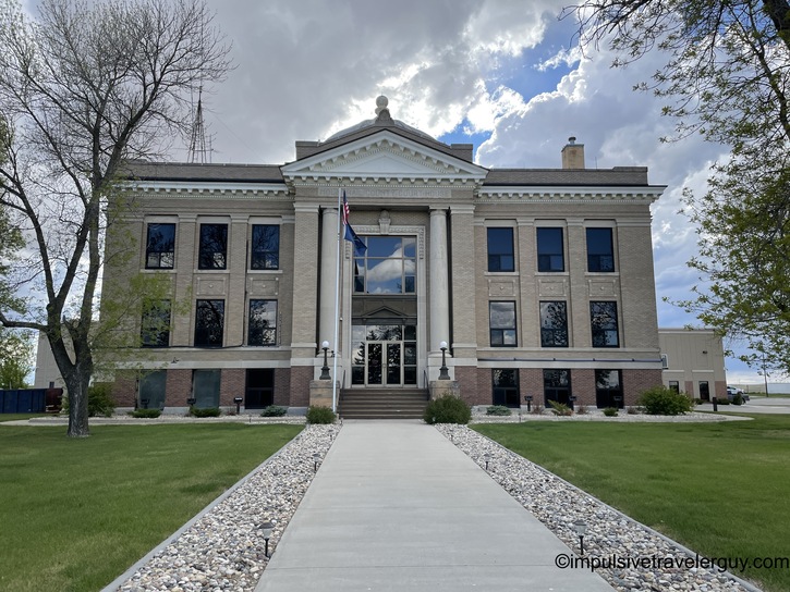
After taking pictures near the water and getting ready for the day, I made it to the Grand Forks County Courthouse.

Classical Beaux-Arts style county courthouse with columned entrance, symmetrical facade, evergreen trees, and well-maintained lawn

I needed to go to the bathroom and figured I’d find a gas station along the way since I needed to fill up anyway. I kind of forgot that much of this country isn’t operating on a 24/7 schedule. I pulled into a gas station at around 6:30 AM, but it was closed. Fortunately, I was able to at least get gas by paying at the pump. I was actually really curious to see what movies this place had to rent.

Industrial commercial building with

I was taking US-81. I find this road especially interesting since it was the main road to Austin, TX before the interstate system. For my travels, it was still the main road.

Rural North Dakota highway with US Route 81 North sign, farmland on both sides, and grain elevator visible in distance

One thing I’m getting good at from all my travels is spotting bathrooms, no matter how primitive. I found this park along the way that still had a pit toilet and a very primitive way of keeping the stall door shut.

Concrete block public restroom building in park setting with Interior of basic public restroom showing white painted concrete blocks, wall-mounted toilet paper dispenser, and composting toilet Close-up of damaged green metal door with peeling paint and makeshift rope handle repair

The next county I made it to was Walsh County.

Art Deco influenced county courthouse with concrete block construction, moderne styling, half-mast flag, and landscaped grounds

By now, I was getting off the US highways and onto the state roads.

Straight rural highway with North Dakota Route 18 North sign, flat agricultural fields, and tree windbreak on horizon

Soon I was at Pembina County.

Neoclassical courthouse with ornate entrance portico, eagle sculptures on roofline,

After that, I made it to Cavalier County.

Modern institutional building complex with brick and concrete construction in small town setting with decorative street lamps

On the drive to Nelson County, it started to rain, but that didn’t really slow me down.

Completely flat North Dakota prairie landscape with two-lane highway stretching to horizon under overcast sky Modern brick county courthouse with glass block details and decorative tower element, surrounded by mature trees and lawn

My next stop was Ramsey County.

Mid-century modern institutional building with horizontal bands of windows, curtain wall facade, evergreen trees, and parking lot

On my way to Benson County, I drove past some beautiful lakes. I’ve always thought of North Dakota as flat prairies so it was a pleasant surprise seeing these lakes.

Causeway or dam road stretching across large reservoir with water visible on both sides and rocky riprap shoreline Large lake or reservoir shoreline with rocky riprap bank, sparkling water surface, and distant tree-covered islands under cloudy sky

The Benson County Courthouse was also nice and historical.

Historic Victorian-era brick courthouse with tower, decorative metalwork sign reading

Towner County also had a historical-looking courthouse.

Small-town courthouse with tan brick facade, white gabled front, arched entrance, and stone foundation accents

Rolette County looked more like a standard government building.

Modest two-story tan brick county building with half-mast flag, symmetrical window arrangement, and manicured landscaping

I was really starting to enjoy the clear blue skies when I got to Bottineau County.

Driver's view of North Dakota prairie highway with sign for Bottineau, scattered white clouds in blue sky, vast agricultural fields Modern low-rise concrete county government building with large parking lot, flagpoles, and contemporary institutional architecture

Next up was Piece County, which was also in the town that was the geographical center of North America.

Pierce County Court House with neoclassical facade, prominent columned entrance portico, and ornamental details viewed through trees Stone monument marking

A little bit later I was at McHenry County.

McHenry County Court House with classical dome, yellow columned portico, symmetrical brick facade, and central walkway through lawn

And then Ward County.

Monumental Art Deco or PWA Moderne courthouse with tall vertical window bays, limestone facade, and modernist attachment

While driving to Renville County, I took in some scenery of a back gravel road.

Straight gravel county road through North Dakota farmland with harvested fields, grass ditches, and dramatic cumulus clouds

That didn’t slow me down much and I was soon at the Renville County Courthouse.

Stutsman County Court House with Art Deco brick facade, vertical pilasters, and mid-century modern institutional styling

I could tell I was getting further west when I saw signs to watch out for moose.

Highway view through windshield showing North Dakota Route 5 West sign, approaching storm clouds, and endless prairie landscape

The terrain was also getting hillier.

Long perspective down rural North Dakota highway with dramatic cloud formations filling sky above flat prairie horizon

Before you know it, I was in Burke County.

Elegant Art Deco courthouse in red brick with curved corner entrance, limestone trim, and sophisticated 1930s architectural details Rural grain elevator complex with multiple silos and processing equipment dominating small town landscape under billowing clouds

The clouds were starting to build again as I made it to Mountrail County.

Empty parking lot with simple white community building under dramatic storm clouds with dark and light contrasts Neoclassical county courthouse with pediment, columns, and ornamental dome detail, framed by bare trees with concrete walkway and white rock landscaping

I drove past the Continental Divide into Divide County.

Driver's view of Continental Divide crossing sign showing elevation 3,267 feet on Montana prairie highway under cloudy sky McKenzie County Court House from 1917 with elaborate Beaux-Arts design, decorative dome with ornament, and symmetrical tan brick facade

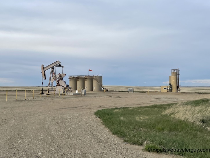
Divide County was the last county in North Dakota I visited. Judging by the increasing volume of pumpjacks, I knew was in oil country.

Oil pump jack with storage tanks in barren North Dakota landscape under gray sky, representing Bakken oil field infrastructure

It wasn’t long before I hit the Montana state line.

Welcome to Montana state sign featuring Tyrannosaurus Rex skull graphic with grain elevator and railroad crossing in background

My first county in Montana was Sheridan County.

Modern Sheridan County courthouse with Art Deco influences, white stucco facade, geometric detailing, and evening light

The Daniels County Courthouse looked something out of the Wild West.

Historic two-story white clapboard building with covered porch and balcony labeled

There was also some nice color in the sky.

Small-town main street at dusk with colorful sunset clouds, modest commercial buildings, and lone parked car

It was now getting dark and I figured I’d drive to the next county, find a place to sleep, and then pick up where I left off in the morning.

Perfectly straight Montana highway perspective view across completely flat prairie under gradient blue sky at dusk

I parked on some residential street in Wolf Point and slept for the night in the back of the car. I got up early in the morning to start my day and visit the Roosevelt County Courthouse.

Quiet small-town residential street at sunset with large trees, modest homes, and pink-orange clouds in pastel sky Roosevelt County Court House at dusk, Art Deco white building with arched entrance details and illuminated entry against sunset colors

The roads were wide open and soon I was in Valley County.

Early morning Montana highway drive with dramatic sunrise clouds, power transmission lines, and endless agricultural fields Valley County Courthouse, modern low-rise building with 1970s architecture, brick and concrete construction, landscaped lawn

Phillips County was next on the list.

Elegant 1920s red brick courthouse with ornamental details, central staircase entrance, decorative cornice, multiple flagpoles

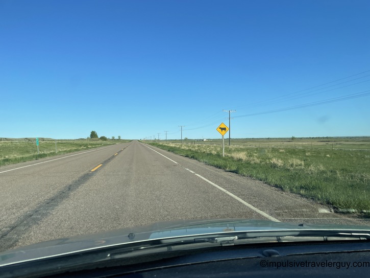
A while back, I was seeing signs for moose. Now there were signs for cattle.

Montana two-lane highway stretching to horizon across completely flat prairie with deer crossing warning sign

If I wasn’t watching for either of those, there was plenty of road construction to also watch out for.

Rural Montana highway with orange diamond-shaped 55 mph speed limit sign and scattered farmsteads visible in distance Gravel county road through Montana farmland with grain elevator visible ahead and unpaved surface typical of rural infrastructure

The road construction did slow me down a bit, but I was still able to make decent time and get to Blaine County.

Contemporary county government building complex with modern tan brick architecture, large windows, accessibility ramps, weeping willow tree

Up next was Hill County.

Hill County Court House, imposing Art Deco limestone building with symmetrical facade, central entrance stairs, ornamental details

Montana is a lot like Texas with its high speed limits on the two-lane roads. The speed limit during the day is 70mph, but one thing that will slow you down is getting behind someone pulling a camper.

Following white semi-truck on Montana highway through vast prairie landscape under clear blue sky with minimal horizon features

After spending some time behind the slow camper, I made it to Liberty County.

Mixed-style county building combining historic red brick section with modern tan stucco addition, creating asymmetrical facade

My next stop was Toole County, where I was greeted by a friendly courthouse cat.

Art Deco style courthouse perched dramatically atop grass-covered hill with stone retaining wall and central staircase entrance Orange and white long-haired cat standing on courthouse entrance steps with tail raised, casting shadow on concrete

On my drive to Glacier County, I see there was an Amtrak train running parallel to the highway. Maybe someday I’ll take the train somewhere.

Amtrak Empire Builder passenger train crossing Montana prairie on parallel track next to rural highway under clear sky

It only took a little bit more driving to get me to Glacier County.

Art Deco courthouse from 1938 with symmetrical facade, vertical window emphasis, ornamental entrance, and stepped roofline details

While I was mainly taking two-lane highways, I finally was able to get some Interstate driving in. Montana was great with their 80mph speed limits!

Montana highway climbing grade with speed limit 80 mph and truck speed 70 mph signs visible on roadside

After some fast driving, I was in Pondera County.

Symmetrical Art Deco county courthouse with dark entrance panel, vertical window details, eagle emblem, manicured lawn

The wide-open roads also started including some mountain scenery in the distance.

Montana two-lane highway with 70 mph speed limit and 65 mph night limit signs, surrounded by harvested grain fields Vast Montana agricultural landscape with harvested wheat field in foreground and snow-capped Rocky Mountain peaks on distant horizon

It was nice enjoying the scenery and it made the drive to Teton County fast.

Victorian Italianate courthouse with central tower, ornate details, symmetrical design, manicured lawn, evergreen trees

I was then soon in Cascade County.

Classical revival courthouse with prominent dome, columned portico, cream-colored facade, surrounded by mature evergreens and lawn

On my way to the next county, I found a scenic overlook.

Missouri River winding through eroded badlands landscape with exposed geological layers and green riverside vegetation Steep eroded hillside along Missouri River with exposed sedimentary layers, abandoned railroad tracks, muddy water

This was followed by a bridge underpass that was small enough to only fit one car at a time.

Rural Montana highway approaching yield sign and low railroad underpass through eroded badlands terrain

Next up was Chouteau County.

Ornate Victorian red brick courthouse with elaborate tower, arched windows, stone trim, classical details

My drive continued to become more hilly and mountainous.

Montana highway through badlands with distinctive layered sedimentary hills and sparse sagebrush vegetation under clear sky Straight Montana highway with unusual halo or sun dog atmospheric phenomenon visible in sky above rolling prairie

The increasingly scenic drive got me to Judith Basin County.

Simple three-story dark brick county courthouse with corner tree casting shadow, minimal ornamentation, clear sky

Fergus County was the next stop on the list.

Elaborate Victorian courthouse with central dome, stepped parapet details, ornamental brickwork, showing weathered patina

Later, I got to Petroleum County.

Two-story early 20th century county courthouse in pale stone or concrete with simple neoclassical details on small-town street

I knew I was in a very desolate area. Just as I had seen in desolate parts of Texas, the roads around the courthouse in Petroleum County were unpaved.

Abandoned weathered wooden homestead building along rural Montana gravel street with scattered trees and sparse development

I don’t mind a bit of desolation. I find it relaxing to drive the open roads.

Montana highway stretching perfectly straight to horizon across prairie with prominent tar-filled crack repairs visible in pavement

When I visited Garfield County, there were very few paved roads. Basically, the road became unpaved right after it got to the courthouse.

Industrial brick building complex with tall chimney in small Montana town, mid-20th century institutional architecture

I also started to realize that I had not had cell phone reception for probably 150 miles. It was starting to get late and I knew I had limited daylight left. I may be able to do another county or two with the daylight left, but I was nervous about being in the middle of nowhere at night with no cell phone reception. I rarely passed a car on many of these highways, so I decided I would use the remaining daylight to get back to the Interstate. I drove on the unpaved roads back to the paved highways.

Rural Montana town street view with RV, trucks, modest homes, and unpaved roads typical of small prairie communities Highway cutting through badlands at sunset with exposed tan sedimentary rock formations flanking road in golden light

As you can see, the roads were narrow and windy and there wasn’t much margin of error on the side. Many times, there was a big drop-off. The antelope were also out and about, so I was trying to make the best time I could but also had to be super careful.

Just as I thought I was making good time, here came some more road construction that slowed me down!

Gravel road through rolling prairie hills at sunset with golden hour lighting on landscape and clear blue sky

At this time I was getting nervous since I had been several hours without cell phone reception. I was wondering if Victoria had texted me and was getting concerned that I hadn’t responded in a while. I figured I’d have cell phone reception near the Interstate, but I was now being slowed down. It took a while before I finally got out of the construction and onto better roads.

Straight Montana highway at golden hour with gentle hills, prairie grassland, and warm sunset light on pavement Montana highway at dusk with dark blue sky transition and prairie landscape visible in fading twilight

I made it to I-94 and also was able to call Victoria. I was tired and found the first rest stop I could near the Montana-North Dakota line. I climbed into the back seat of the car, got some sleep, and then woke up early in the morning to get a start on my 13-14 hour drive back home.

Three tall power transmission poles silhouetted against sunset sky on prairie hillside with orange and purple gradient

I was soon back in North Dakota and it was another straight shot on I-94 back to Madison.

Four-lane Montana highway at sunrise with overhead road sign visible against orange and pink dawn sky Sunrise highway view with sun breaking over distant hills, creating orange glow on horizon with contrail in sky above Interstate highway with rest area exit signs, tree-lined median, scattered cumulus clouds, and dusty windshield evidence Multi-lane interstate through wooded area with concrete barriers, traffic, billowing white clouds, and lush green vegetation

I ran into traffic a few times along the way, but I was able to get home around 7:30 PM. I would say this was a productive trip that ultimately got me 35 new counties visited.

Mobile phone screenshot showing completed 3,192-mile road trip route from upper Midwest through Montana back to Wisconsin

See more blog entries here